Following the catastrophic 1977 floods, Congress, via the 1981 Water and Energy Appropriations Act, tasked the U.S. Army Corps of Engineers with assessing flood risks in three Appalachian river basins, targeting protection for five key communities, including Grundy, Virginia.
From the early 1980s to the mid-1980s, the Corps’ Huntington District collaborated with Grundy’s mayor and town council to evaluate structural flood control options—measures like dams and channel improvements aimed at shielding existing homes and businesses from floodwaters.
Options included an upstream reservoir, floodwalls, an open-cut channel akin to Pikeville, Kentucky’s Cutoff Project, a diversion tunnel for the Central Business District (CBD), and various channel widening and lengthening proposals.
After over six years of study, structural solutions proved unfeasible for several reasons:
Recognizing the need for viable solutions, the Corps and Grundy shifted to nonstructural alternatives—strategies reducing flood damage by managing floodplain development, such as zoning, National Flood Insurance Program participation, flood warning systems, emergency plans, flood-proofing structures, and relocating buildings from high-risk zones.
Grundy formed a task force, led by attorney Ron King, representing diverse business interests, to collaborate with the Corps starting in July 1989.
Early planning showed voluntary flood-proofing and evacuation feasible for areas along Slate Creek and the Levisa Fork outside the CBD. However, the downtown’s aging, common-wall structures and deep 1977 flooding rendered these measures impractical there.
A novel solution emerged: relocating the CBD to a flood-safe elevation. Initial plans involved rebuilding on elevated platforms in the existing area, requiring phased demolition and reconstruction to minimize business disruption. These proved unworkable due to timing and impact concerns.
The task force proposed redeveloping the adjacent P.V. Dennis Elementary and Grundy Jr. High School site instead. The Corps revised plans to use this location, improving transition feasibility. The town council, on the task force’s advice, selected Plan 3, which included:
Despite preference for Plan 3, the 25% non-federal cost-share—approximately $25 million—remained unaffordable for Grundy.
Concurrently, the Virginia Department of Transportation (VDOT) studied U.S. Route 460 improvements near Grundy. Initially separate, these efforts aligned after State Delegate Don McGlothlin and Congressman Rick Boucher encouraged collaboration. Coordination revealed cost-saving potential by merging the Corps’ flood control with VDOT’s highway project.
The joint Plan 3A integrated flood protection with a U.S. 460 rerouting through Grundy, rather than bypassing it. VDOT’s land acquisitions offset the 25% non-federal share, relieving Grundy of costs. Authorized by the Water Resources Development Act of 1996, Plan 3A evolved with refinements to minimize disruption.
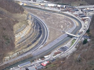
The Appalachian School of Law’s occupation of the original redevelopment site prompted selection of the depot site instead. VDOT invested $96 million, razing historic downtown structures like the Lynwood Theater for a levee-protected roadway. The Corps, with nearly $100 million, rerouted rail tracks and excavated 2.4 million cubic yards of rock—enough to cover 68 football fields 20 feet deep—completing a $200 million transformation.
Source: U.S. Army Corps of Engineers, Grundy Flood Control Project
Acknowledgment: Thanks to Grok, an AI by xAI, for formatting assistance. The historical account is compiled from Corps and press sources by me. —Lewis Loflin
